Facilities Research/training vessel
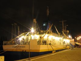
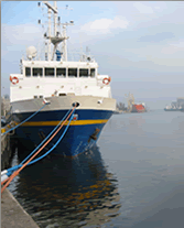
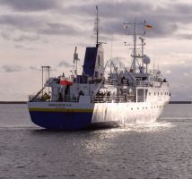
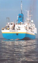
m/s Nawigator XXI – the modern research/training vessel owned by the Maritime University of Szczecin

Nawigator XXI photo gallery
Vessel's particulars:
Length overall: 60,3 m
Length between perpendiculars: 54,13 m
Beam: 10,50 m
Height to the main deck: 4,20 m
Draft: 3,15 m
Vessel’s Class
The vessel was designed and built according to the regulations of Polski Rejestr Statków for the class KM I L3 sp. The vessel meets the subdivision requirements for specialist vessels with specialist personnel of up to 50 persons in accordance with the PRS regulations, part IV, paragraph 5.5.
Vessel’s Deadweight
The vessel’s deadweight at draught of about 3,15 and at even keel, in the sea, is about 300 tons. The deadweight comprises fuel for the main engine and generators, oils, fresh water, supplies, the crew with their luggage (research equipment, spare parts and stocks are included in the mass of the empty vessel).
Register Capacity:
Capacity GT = 1208 RT
Capacity NT = 362 RT
Vessel’s Speed
The vessel’s speed during sea tests at the draught about 3 m in deep water (7-8 draughts of the vessel) at even keel, the wind exceeding 3 B and the state of the sea 2, is about 13 knots at 90% MCR of the main engine.
Navigation and Operation Range
The vessel has the fuel supply for the 4000 nautical miles navigation range at the speed of about 12.7 knots. Supplies of fresh water and food are expected for 20 days.
Load Capacity
Containers’ volume:
- fuel (spare tanks) - about 91;3 m3
- oils - about 2,7 m3
- freshwater - about 38 m3
- ballast - about 257 m3

Regulations and Conventions
The vessel complies with the requirements of the following regulations:
Classification regulations regarding sea ships’ structure - PRS 1990, with amendments till 1995; non-classification regulations regarding ships’ equipment - PRS 1990 and the part II from 1993
Regulations regarding sea ships’ crane devices PRS 1990
International Convention for the Safety of Life at Sea, 1974, and amendments of 1978 and 1983
International Convention on Load Lines, 1966 as Modified by The 1988 Protocol Relating Thereto
International Convention on Tonnage Measurement of Ships, 1969
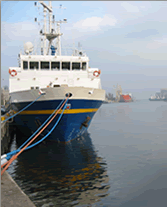
m/v Nawigator XXI – the modern research/training vessel owned by the Maritime University of Szczecin has been built at Gdańska Stocznia Remontowa. The ceremony of the hoisting of the flag was held on 30th January 1998.
The vessel is used for:
• monitoring of the Baltic Sea and other sea basins,
• taking samples of water at various depths and in various sea regions,
• taking samples of soil from the surface of the seabed and from the ground, processing the taken samples in the laboratories, transmitting the data to the onshore recipients,
• students’ training in the field of navigation, engine operation, deck equipment,
• research co-operation.
The vessel is adapted to the 1st area of navigation according to the PRS regulations, i. e. to navigation on the North Sea and other open seas within the distance of 200 nautical miles from the port of call, with the allowable distance between two ports of call up to 400 nautical miles and navigation on the Baltic Sea and other enclosed seas.
Vessel’s Equipment
The vessel’s construction and technical parameters have been adapted to research-training demands of the Maritime University of Szczecin and other research or higher education institutions. The vessel is intended for students’ training and marine environment research.
Nawigator XXI has been fitted with the up-to-date integrated data management system TRAC-C made by Kelvin Hughes and the latest equipment for hydrographic surveys. Analysis of the taken research material can be done ashore or in one of the onboard laboratories. The bridge navigational equipment has been integrated in NINAS 9000 system made by Kelvin Hughes. The NINAS 9000 system is fully modulated and can be adapted to individual demands.
Navigational Bridge Equipment
Radio communications GMDSS:
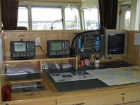
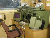
Sailor Compact 2000 radio station
Additional GMDSS equipment:
INMARSAT B terminal - SATURN Bm
EPIRM beacon - Kelvin Hughes (406-2A)
Radar transponder - Kelvin Hughes (SART)
Navtex receiver - Shipmate RS-6100 Aplidan internal communication system
Amplidan Commander IV communication system
Aplidan Microstwitch FTTU-032 exchange
Amplidan CAS-12 000 system
Positional systems:
GPS receiver - Trimble NT-200
DGPS receiver - Trimble NT-200D
Integrated Data Management System Kelvin Hughes NINAS 9000:
Radar - Kelvin Hughes NUCLEUS 2-6000A/2/SD - band S
Radar - Kelvin Hughes NUCLEUS 2-6000A/27/D - band X
Multifunctional Data Monitor - NUCLEUS
Navigational Parameters Indicator
MASTER YEOMAN Electronic Navigation Table
2 training radar indicators - NUCLEUS 2 5000A
Control system:
Class A magnetic compass - Reflecta 1 Fiberline
Gyro-compass - Anschuetz Standard Compact
Rudder indicator
Course control automatic system
Other Navigational Equipment:
Weather facsimile receiver - Furuno FAX-207
Echosounder - Skipper GDS-101
Doppler biaxial log - Sperry SRD-421 S
Research Equipment
Integrated Data Management System TRAC-C (Kelvin Hughes U.K.)
This most modern system enables the acquisition, monitoring, distribution and redistribution of data. Data watching and registration is possible thanks to the system of interfaces which are being controlled by the processes system or by the network software.
System parameters:
• system of programmed interfaces
• geodetic standards providing
• data monitoring
• multilevel operating in Windows NT system
• network support of system operating
• measuring data management
• data protection system
• possibility of a remote control
• input/output parameters definition by the user
BOTTOMCHART COMPACT SHALLOW WATER MK II (ELAC Nautic GmbH - Germany)
Hydrographic measurements are in accordance with the IHO SP-44 requirements. Particularly good results in shallow waters and in the environment generating a great number of secondary bunches (rivers, canals, etc.). Maximum horizontal coverage: 940 m (at 110 m depth). Maximum measurement depth: 600m. The perfect resolving power and very strong sidelobe rejection (max. 36 dB) due to applying of the narrow radiation characteristic. Automatic calibration system. Graphic data display of seabed shapes in the following forms: profiles, izobaths, three-dimensional, half-lighted and others. Operating frequency - 180 kHz. The number of beams – 126. Transducers: two compact transducer arrays 255x180 mm installed in the underwater part of the hull. Lateral heels, longitudinal heels and the immersion impact on data processing compensation in progress. Echosounder integrated with TRAC-C system.
Probe HMS 1820 CTD (MARIMATECH - Denmark)
The device for measuring the following parameters:
- salinity (accuracy +/- 0.1 per 1000)
- temperature (+/- 0.1 °C)
- depth (0,25% scope) and velocity of sound (+/- 1 m/s)
The sounder makes it possible to record data automatically at pre-set time or depth intervals, and to transfer data to the HydroStar software, which enables the correction of data logged by the multibeam sounder.
Remote-operated vehicle (ROV) - OFFSHORE HYBALL (HYDROVISION - U.K.)
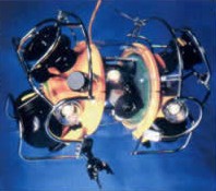
Optical penetration in the full range of angels due to a transparent cover and a camera with 360° vision.
The system comprises:
- a compass
- a gyro-compass
- a jaw manipulator
- colour and black-and-white video cameras with a lighting system to be adjusted.
ROV Offshore Hyball enables automatic control of draught, course and speed which makes it a perfect tool for technical inspections of all kinds of hydrotechnical constructions or cables and pipelines underwater.
Sonar localization enables the localization of objects which are out of the range of the camera – even in 180 m distance.
The vehicle can lower to 300 m depth. Admission and control signals for a robot as well as video camera images are being transmitted through a special cable. 2 sets of cables – 200 m and 300 m which can be connected together – the device can operate in the 500 m distance from the control station. The system has an additional hydroacoustic vehicle-positioning system.
Seabed vibrocorer SVC 350 (SEABED BV - Holland)
The device is designed for taking cylindrical core samples of the seabed. The motive power is supplied by a powerful synchronized vibro-unit controlled from a containerised control display connected to the vibration head. Weight: 1100 kg, bottom penetration: 3.5 m, core diameter: 108 mm, maximum operating depth: 150 m. The device is used in pipeline lying, drilling, installation, research work, etc.
Weather station (AANDERA INSTRUMENTS DATALOGGER 3060)The complete weather station for measuring the wind speed and directions, atmospheric pressure, temperature and air humidity. The station is integrated with the TRAC-C system.
Subbottom profiler
The device for studying the structure of the seabed. The echosounder enables setting geological layers even 80 m under the bottom.
Side Scan Sonar
Side sonar for detecting objects on the bottom. The objects are displayed in the form of elements throwing a theoretical shadow. Thanks to such visualization of the seabed shape the image similar to a photograph can be obtained. Such image and data from a multibeam echosounder enable the interpretation of survey results and initial identification of objects such as wrecks.
Probe HMS 1820 CTD (Marimatech – Denmark)
The device for measuring the following parameters: salinity (accuracy -+0,1 per 1000), temperature (accuracy -+0,1C) and depth, indispensable for the determination of the velocity of sound at various depths (with accuracy of -+0,1 m/s). the echosounder makes it possible to automatically record data at pre-set time of depth intervals, and to transfer the data to the HydroStar software, which enables the correction of data logged by the multibeam echosounder.
The sub-bottom profiler Edgetech SB-216S
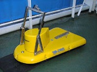
This echosounder can perform non-invasive analysis of the sea bottom. After calibration, the operator receives an image of geological strata of the bottom to 80 meters into the ground. The echosounder has wide applications in geological investigations and in the preparatory work preceding water engineering constructions. The technical parameters:
a) frequency range: 2-10 kHz
b) beam width: 15-20
c) vertical resolution: 10cm 2-10kHz; 8cm 2-12 kHz; 6cm 2-15 kHz
d) typical penetration depth: 8m – sand, 100m – clay
e) power output: 2kW
Bottomchart compact shallow Watermultibeam Echosound MKII (L3 Elac Nautic GmbH – Germany)
The echosounder MKII is an extremely effective device for hydroraphic survey. It allows gathering data on seabed shape quickly and accurately. The accuracy of hydrographic measurements is in accordance with the IHO SP-44 requirements. Thanks to the system of attenuation within the sidelobes, the echosounder is perfect in measurements of narrow channels and fairways.
Thechospounder’s technical data:
a) number of beams: 126
b) angle between extreme beams: 156
c) operating frequency: 18 kHz
d) maximum measurement depth: 600m
e) maximum horizontal coverage: 940 m (at 110m depth)
f) transducers: two compact transdrucer arrays 255x180 mm installed in the underwater part of the hull
g) online compensation of ship’s motion with real-time inputs from roll/pitch/heave sensor TSS-335B
h) data logging in variety of formats, enabling data export to e.g. the Caris Universal package
i) graphic data display during measurements at the operator’s terminal (on the navigating bridge)
j) HydroStar software for echosounder operation control
Side scan sonar OMS 460 Octopus, towed fish EdgeTech 272-TD
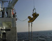
The device enables gathering information from hydroacoustic measurements and its graphic display as objects projecting shadows on the bottom. The towed fish can operate in two modes high resolutions (500kHz) and low resolution (100 kHz).
CAPRIS HIPS Package
Application: preliminary processing of data logged by the multibeam echosounder, graphic data display (profiles, isobaths, 3D image, DTM models). Besides, the package enables the export of data to other system used for sea area chart drawing.
RECORDER EPC
This recorder enables printing on paper tape data recorded by a sub-bottom profiler or the side scan sonar.
Seabed vibrocorer SVC 350 SEABED
This device is designed for taking cylindrical core samples of cohesive seabed. The motive power is supplied by a powerful synchronized vibro-unit controlled by a containerized display connected to the vibration head. The echosounder has been installed aft with a launching device.
a) weight 1100kg
b) bottom penetration: 3,5m
c) core diametet: 108 mm
d) maximum operating depth 150m


